
CAREER AND ENTREPRENEURIAL OPPORTUNITIES IN SOCIAL STUDIES
- Social studies is a learning area that includes History, Geography and Citizenship
- The study of social studies provides us with career and entrepreneurial opportunities in different fields.
- Careers are occupations undertaken for a significant period of a person’s life and with opportunities for progress in life
- Entrepreneurship is the activity of setting up a business or taking on financial risks with hope of making a profit
Get Junior Secondary Notes- Grade 7 All Subjects
Business Studies Notes
Computer Science Notes
Life Skills Notes
Social Studies Notes
Importance of social studies for personal development and service to humanity
- Social studies prepares learners to join various career pathways
- Learners are able to utilise available resources to come up with entrepreneurial projects which help them meet their needs.
- By learning political development and governance learners are exposed to different styles of leadership
- By understanding systems of government, learners are able to make informed decisions once they take up leadership roles in future for the benefit of the community
- The historical understanding of some prominent people in the past is key in shaping learners future
- Social studies encourages learners to appreciate different cultures, values and traditions from national and global perspective which can be adopted in our locality
- learners are able to integrate key aspects of the constitution such as integrity when making decision about governance
- Learning of key aspects on democracy, rule of law, responsible citizenry helps learners living harmoniously in the society.
- Skills and knowledge in personality, human identity and personal well being in promoting inner peace are all meant to enhance understanding of personal growth and development
- Research skills in field work equip learners with data collection, analysis and presentation skills that will help in solving problems affecting our society
| Importance of social studies | ||
| Personal development | Service to humanity | |
| 1 | Helps one to understand the real world around us | Helps us to utilize the available resources to serve humanity |
| 2 | Helps us to become good citizens | Helps us to appreciate and relate well with other people |
| 3 | Helps us to know the current affairs | |
| 4 | ||
| 5 | ||
| 6 |
Career opportunities related to social studies
- Law -Advocate -Lawyer
- Geology –
- Museology –
- Cartography
- Urban planning
- Meteorology and climatology
- Aviation
- Archaeology
- Medicine
- Teaching
- Survey
- Engineering
| Geography | History | Citizenship |
| Land economics | Archaeology | Public administrator |
Entrepreneurial opportunities for social studies
Some of the entrepreneurial opportunities for social studies in our socisty include
- Pottery
- Basketry
- Ecotourism
- Horticulture
- Agro forestry
- Fishing
- Dairy farming
Gender stereotypes associated with career choices and entrepreneurial opportunities in social studies
Gender is the state of being male or female in relation to social and cultural roles.
Stereotypes are fixed general ideas or images that assume that a person behaves in a particular way.
Stereotypes limit aspirations and development of talents.
They create gender differences.
These gender differences ought to be addressed using appropriate strategies.
A strategy is a careful plan or method of dealing with an issue
We can address gender stereotypes in career and entrepreneurial opportunities related to social studies through the following strategies
- Committing and encouraging both males and females to take a full range of careers and business opportunities
- Ensuring representation of both genders in leadership
- Treating both males and females equally by using texts and circular that does not promote gender bias
- Develop policies, law and decision making process that represent both males and females
Recognising biological difference devoid of stereotypes in career choices and entrepreneurial opportunities in social studies
- There are biological differences between male and female people.
- Biological difference should never be a hindrance to one’s career choice and entrepreneurial opportunities
- Both male and female should be given equal opportunities to pursue their dreams
Demonstrating respect for one’s gender identity in pursuit of social studies careers and entrepreneurial opportunities
NATURAL AND HISTORIC BUILT ENVIRONMENT IN AFRICA
MAPS AND MAPWORK
A map is a representation of the earth or part of it on a flat surface.
Position of Africa
- Africa lies between latitude 37ºN and 35ºS and on longitude 18ºW and 52ºE.
- Separated by water from all other continent except at the point where it joins Asia.
- Mostly Easterly point is called ras hafun(cape guardafui)
- Mostly westerly is cape verde
- Mostly northerly is cape bon
- Mostly southerly is cape agulhas
- Africa is connected to sinai peninsula by suez canal
- Separated from Spain by strait of gibraltar
- Separated from Arabia by strait of bab el-mandeb
Shape of Africa
The northern half is very wide while the southern is much narrower
At the cape guardafui extends outwards in the shape of a horn therefore the horn of Africa
Size of Africa
Africa is the second largest continent in the world
Has an area of about 30.3 million square kilometres (20% of the total land surface)
It measures 8000 km from north to south and 7400km from east to west
Other continents
- Asia – 43608000km2
- Africa – 30335000km2
- North America – 25349000km2
- South America – 17611000km2
- Antarctica – 13340000km2
- Europe – 10498000km2
- Australia – 8923000km2
Countries that makes up the Africa continent
Africa has the largest number of countries in the world making o total of 55 countries
- Algeria 2381741km2
- Angola 1246700km2
- Benin 115773km2
- Botswana 600372km2
- Burkina faso 274200km2
- Burundi 28490km2
- Cameroon 475900km2
- Cape verde 7275km2
- Central africa republic 622984km2
- Chad 1284000km2
- Comoros 2117km2
- Congo 34965km2
- Cόte d’ ivoire 322463km2
- Djibouti 23310km2
- DR congo 2345409km2
- Egypt 1101449km2
- Equatorial guinea 28051km2
- Eritrea 124320km2
- Ethiopia 1221900km2
- Gabon 267667km2
- Gambia 11369km2
- Ghana 238537km2
- Guinea 245957km2
- Guinea bisau 36125km2
- Kenya 582648km2
- Lesotho 30460km2
- Liberia 111369km2
- Libya 1775000km2
- Madagascar 592900km2
- Malawi 118484km2
- Mali 1240192km2
- Mauritania 1030700km2
- Mauritius 2040km2
- Morocco 724730km2
- Mozambique 802000km2
- Niger 1267000km2
- Namibia 824295km2
- Nigeria 923773km2
- Rwanda 26338km2
- Sӑo Tome & principe 964km2
- Senegal 196192km2
- Seychelles 453km2
- Sierra leone 72325km2
- Somalia 626541km2
- South africa 1221037km2
- South sudan 644329km2
- Sudan 1886068km2
- Eswatini 17368km2
- Tanzania 947419km2
- Togo 56785km2
- Tunisia 164154km2
- Uganda 236036km2
- Western sahara 252120km2
- Zambia 752618km2
- Zimbabwe 390759km2
The largest country in Africa is Algeria while the smallest is Seychelles.
Offshore island also form part of Africa;
- Seychelles
- Sao Tome and principe
- Mauritius
- Comoros
- Madagascar
- Cape verde
Locating places and features on a map using latitudes and longitudes
- When giving the position of a place or features we with start with the latitude and then longitude
Major latitudes and longitudes
- Major longitude is called prime meridian also called Greenwich meridian
- In Africa it passes through:
- Ghana(Accra)
- Algeria
- Burkina faso
- Mali
- All other longitudes are measured and named from prime meridian up to 180 ̊ on both sides
- Major latitude are 3 passing through Africa
- Equator 0 ̊ – divides Africa into two parts
It passes through;
- Gabon
- Congo
- DR congo
- Uganda
- Kenya
- Somalia
- Tropic of cancer 231/2 ̊ north of equator
It passes through;
- Western sahara
- Mali
- Mauritania
- Algeria
- Libya
- Egypt
- Tropic of capricorn 231/2 ̊ south of equator
It passes through:
- Namibia
- Botswana
- South africa
- Mozambique
- Madagascar
- Other important lines of latitude are far from africa are:
- Arctic circle 661/2 ̊N
- Antarctic circle 661/2 ̊S
| Place | Degrees north | Degrees south | Degree east | Degrees west |
| Kenya | 5ºN | 4½º S | Between 34º W AND 42º E | |
| Algeria | ||||
| Abidjan | ||||
| Eswatini | ||||
| Cairo | ||||
| Capetown | ||||
| Freetown |
| Physical feature | Degrees north | Degrees south | Degree east | Degrees west |
| Lake turkana | ||||
| Namib desert | ||||
| Mt. Kilimanjaro | ||||
| River Zambezi | ||||
| Jos plateau |
Calculating the time of different places in the world using longitudes
- Rotation of the earth- This is movement of earth on its own axis
- Distance between longitudes is measured in degrees
- There are 360 meridians or longitudes
- One complete rotation is 360 ̊
- The direction of the rotation is from west to east i.e. anticlockwise direction.
- One complete rotation takes 24 hours
- All places found in the east of the Greenwich meridian will see sunrise first and therefore they are one hour ahead of those to the west
Effects of rotation of the earth
- Differences in time along different longitudes
- Occurrence of day and night
24hrs = 360 ̊
1hr = ?
360×1 ÷24 =15
Therefore 1hr =15 ̊ or 360 ̊= (24×60)minutes=1440min
̊= 1440÷360 ×1=4min
I Hr the earth covers 15º and 1º it covers 4 minutes
Calculating time of places found to the east of Greenwich Meridian
Example 1
The time in Accra 0 ̊ is 7.00am.calculate time in bermbera 45 ̊E
1hr =15 ̊
? = 45 ̊ = 45÷15×1 =3hrs
So 3hrs is equivalent to 45 ̊ then add 3hrs to 7.00am to get 10.00am
Example 2
Suppose the time at GWM is 12 noon what is the local time at Watamu 40◦E?
Time gained=40×4=160min=2 hours 40min
Local time at Watamu is 12.00+2.40=14.40-1200=2.40pm.
Example 3
At Dar-es-Salaam 40◦E time is 12pm what is the time at Ecuador 40◦E?
40◦+20◦=60◦
60×4=240min=4hours
Ecuador is behind in time =12.00-4=8 am.
NB
- When calculating time to the east of Greenwich meridian, we add the time difference to the local time.
Calculating time of places found to the west of Greenwich Meridian
- When calculating time to the west of Greenwich meridian we subtract the time difference to the local time
Example 1
A plane leaves off in New York, 74ºW at 7 am local time. What is the local time in Stockholm 18ºE
NB
- If the places are on the same side subtract the degrees to get the difference and add or subtract from the reference time depending on which side the place is.
Pictures, plan and maps
| Picture | Plan | Maps |
| Image of a real object | Outline of something drawn to scale | Representation of the whole or part of the earth’s surface drawn to scale |
| Gives details in their visible shapes and sizes | Also drawn as if a person was directly above the ground | Shows outline of objects on the ground |
| Can be inform of free hand, drawing, painting or a photograph | It represents a very small place | Drawn as if the drawer was above the ground |
| Not drawn to scale | The scale is large to show details e.g. house plan | It shows details |
| Gives specific information | Most of the features are indicated by symbols. |
Types of maps
- Topographical maps
This shows selected natural physical features on a small portion of a country.
- Atlas map this is a collection of maps in one volume
- Sketch map maps which are roughly drawn.
A good sketch map should have the following characteristics:
- Neat and clear
- Title
- Frame
- Key
- Compass direction
Importance of maps in day to day lives
- Sketch maps are used to summarise information for easy reference.
- Used for locating other countries.
- Used for comparing sizes of countries.
- For locating climatic regions of different parts of the world.
- Give information on distribution of geographical phenomena e.g. vegetation on the earth’s surface.
- Help travellers to find their way.
- Used to calculate distance of a certain place.
- Used to locate physical features like landforms.
THE EARTH AND THE SOLAR SYSTEM
Solar system is the group of heavenly bodies comprising the sun and the planets.
The origin of the solar system
- The passing star theory
A star with a greater gravitational pull passed near the sun
It attracted large quantities of gaseous materials from the sun
The materials split, cooled and condensed to form planets
The planets were set in orbit by the passing star
- The nebula cloud theory
There was a slowly rotating cloud of dust and gas called Nebula
It cooled and began to contact
Rotation speed increased and successive rings of gaseous materials were formed.
The rings condensed to form planets
The central gaseous material remained as the sun
Size of the earth
Equatorial diameter-12756km
Equatorial circumference-40085km
Polar diameter-39995km
Surface area of the earth-510×106 km2
Water surface – 73%.
MERCURY
Nearest from the sun
Its 58m km from the sun
Has no satellites
Takes approximately 88 earth days to revolve around the sun
Venus
2nd planet from the sun
It’s 108m km from the sun
One of the brightest planets
Can be seen clearly with naked eyes
Takes approximately 225 earth days to revolve around the sun
Slightly smaller than the earth
Has no satellites
Together with the earth they are called twin planets due to having many similarities
Mars
Also called The Red Planet because when it’s observed through a telescope it appears reddish.
The 4th from the sun
Slightly smaller than the earth
Approximately 228m km from the sun
Takes 687 earth days to revolve around the sun
Between Mass and Jupiter there are small celestial bodies called planetoids.
Has no satellite.
Jupiter
5th planet from the sun
Approximately 778m km from the sun
Largest in the universe
Rotates on its own axis at very fast speed
Has flattened poles due to its fast speed of rotation
Has very thick layers of ice on its surface
takes 12 earth years to revolve around the sun
Has 16 satellites
Saturn
6th planet from the sun
Second largest planet
Approximately 1427m km from the sun
Takes 29 ½ earth years to revolve around the sun
Has a ring around it
Has 18 satellites
Uranus
7th planet from the sun
About 4 times bigger than the earth
Approximately 2870m km from the sun
Also rotates very fast
Also has flattened poles due to fast speed of rotation
It appears greenish foe being surrounded by methane gas
Has 8 satellites
Takes 84 earth years to revolve around the sun
Neptune
One of the farthest from the sun
8th planet from the sun
Approximately 4497m km from the sun
Has 8 satellites
Takes 165 earth years to revolve around the sun
Very similar in size, colour and character with Uranus
The shape of the earth
The shape of the earth is called geoid/ovoid/oblate spheroid due to being an imperfect sphere by being wide at the equator and flat at the poles.
The position of the earth in the solar system
The 3rd planet from the sun
The earth and the heavenly bodies make the universe
The only planet that supports life
The home of man
Approximately 149m km from the sun
Takes 365 ¼ days to revolve around the sun
Has one satellite, the moon
Rotation of the earth
Movement of the earth on its own axis (imaginary line through the centre from N pole to S pole
Rotates through 360º
Takes 24 hours (day) to complete 1 rotation
Rotates in an anticlockwise direction (west to east)
Effects of Rotation of the Earth
- Creates day and night because at any one time one side of the earth faces the sun (day) and the other remains in darkness (night).
- Causes deflection of winds and ocean currents in the N hemisphere to the left and in the S hemisphere to the right.
- It causes rising and falling of ocean tides.
- Causes time difference between longitudes
Effects of Rotation of the Earth on human activities
| Effects of Rotation | How rotation affects human activities |
| Day and night | Planning day and night activities |
| High and low tides | Helps in fishing activities Sea transport – |
| Deflection of winds and ocean currents | Triggering of cyclones, hurricanes and tornadoes for example the deflection cause pressure changes which affect ocean currents and movement of wind Growing of crops Aviation or sea transport Causes flooding |
| Time difference | Travelling Education Sports |
Revolution of the earth
- Movement of the earth in its orbit around the sun.
- It’s in anticlockwise direction.
- The orbit of the earth’s revolution is elliptical.
- Takes 365 ¼ days in a year or 366 days in a leap year (every 4 years).
- The sun moves from the tropic of cancer to the equator and then towards tropic of Capricorn and back to the tropic of cancer.
- 21st march and 23rd September are called equinoxes becausethe length of day and night is equal. The sun is vertically overhead at noon at the equator.
- 21st June is called summer solstice because its summer in the N hemisphere. The sun is vertically overhead at noon at the tropic of cancer.
- 22nd December is called winter solstice because its winter in the S. hemisphere. The sun is vertically overhead at noon at noon at the tropic of Capricorn.
- Solstice is the period of maximum tilting of the earth towards the sun.
Effects of the Revolution of the earth
- Causes the four seasons summer, autumn, winter and spring due to the movement of overhead sun causing changes in the heat belt.
- Causes variation of day and night’s lengths due to the earth’s axis being inclined to the path of revolution at an angle of 60◦.
- Equinoxes have equal lengths of day and night.
- Summers have longer days and shorter nights.
- Winters have longer nights and shorter days.
- Causes changes in the altitude of the midday sun due to the earth’s orbit being elliptical.
- Highest altitude during equinox
- Lowest altitude during solstices
- Causes lunar eclipse due to revolution bringing the earth in line with the sun and the moon.
Effects of the Revolution of the earth on human activities
| Effects of Revolution | How revolution affects human activities |
| Changes in the position of midday sun at different times of the year | |
| Varying length of day and night at different times of the day | |
| Seasons |
The internal structure of the earth
A. Crust/Lithosphere
- Outermost layer of the earth
- Made of soils and other loose deposits of sand
- The dominant rocks are granites.
- Extends 0-50km
- Has 2 layers
1. Sial
- Also called continental crust
- Made of light coloured rocks
- Called sial because it’s made up of silica and aluminium.
2. Sima
- Also called oceanic crust
- Mainly made of basaltic rocks which are brittle.
- Called sima because it is made of silica magnesium and iron.
B. Mohorovicic Discontinuity (Moho)
- A definite zone of discontinuity between the crust and the mantle.
- Was discovered by Dr. Andrija Mohorovicic in 1909.
- The Mantle/Asthenosphere
- Layer lying between the crust and the core
- Made of iron and magnesium
- Has two layers
- Upper mantle
- Rocks are more elastic than those of sima.
- Temperature is about 1000◦c.
- lower mantle
- Rocks are like very viscous liquid.
- Temperature ranges between 1000◦c to 3000◦c.
- Gutenberg Discontinuity
A definite zone of discontinuity between mantle and core.
- Core/barysphere/Centrosphere
- The innermost/central layer of the earth.
- Has 2 layers
- Outer Core
- Composed of very dense rocks
- Made up of nickel and iron
- Temperatures are up to 3700◦c.
- Inner Core
- A solid mass of mainly iron
- Temperatures are estimated to be 4500◦c to 5000◦c.
F. The Atmosphere
Layer of gases surrounding the earth.
The earth revolves with it because its held onto it by gravity
It’s about 330km thick.
Composition of the Atmosphere
- Gases-exist as a mixture
- Smoke particles
- Dust particles
- Water vapour
G. hydrosphere
Ocean and seas
WEATHER
Weather is the daily atmospheric conditions of a place at a particular time.
ELEMENTS OF WEATHER
- Temperature
Measure or degree of hotness or coldness of a place
- Humidity
The amount of water vapour or moisture in the atmosphere
- Precipitation
All forms of moisture which fall from the atmosphere to the earth’s surface
Rainfall is a form of precipitation formed from clouds that in form of water droplets
- Atmospheric pressure
- Wind
Moving air on the surface of the earth
- Sunshine
Direct rays of sunlight on the surface of the earth
- Cloud cover
Mass of tiny droplets of water or ice formed through condensation
Analysis and interpretation of weather conditions
Diurnal/daily Temperature range
-Difference between the maximum and minimum temperature for any one day.
Mean Daily Temperature
-Average of the maximum and the minimum daily temperatures.
Mean Monthly temperature
-Sum of mean daily temperatures in a month divided by the number of days in that month.
Mean Monthly minimum Temperature
-Sum of daily minimum temperatures divided by the number of days in that month.
Mean Monthly Maximum Temperature
-Sum of daily maximum temperatures divided by the number of days in that month.
Mean Annual Temperature
-Sum of mean monthly temperatures divided by 12.
Mean Annual Temperature Range
-Difference between the highest and the lowest mean monthly temperatures in a year.
Monthly Rainfall Total
-Sum of rainfall recorded in a month.
Annual Rainfall Total
-Sum of monthly rainfall totals for 12 months.
Mean Monthly Rainfall
-Sum of rainfall totals for a particular month over several years divided by the number of the years of observation.
Mean Annual Rainfall
-Sum of mean monthly rainfall for 12 months of the year.
Factors to consider when siting a weather station
Weather Station
–A place where observation, measuring and recording of weather elements is done
CAREER AND ENTREPRENEURIAL OPPORTUNITIES IN SOCIAL STUDIES
- Social studies is a learning area that includes History, Geography and Citizenship
- The study of social studies provides us with career and entrepreneurial opportunities in different fields.
- Careers are occupations undertaken for a significant period of a person’s life and with opportunities for progress in life
- Entrepreneurship is the activity of setting up a business or taking on financial risks with hope of making a profit
Importance of social studies for personal development and service to humanity
- Social studies prepares learners to join various career pathways
- Learners are able to utilise available resources to come up with entrepreneurial projects which help them meet their needs.
- By learning political development and governance learners are exposed to different styles of leadership
- By understanding systems of government, learners are able to make informed decisions once they take up leadership roles in future for the benefit of the community
- The historical understanding of some prominent people in the past is key in shaping learners future
- Social studies encourages learners to appreciate different cultures, values and traditions from national and global perspective which can be adopted in our locality
- learners are able to integrate key aspects of the constitution such as integrity when making decision about governance
- Learning of key aspects on democracy, rule of law, responsible citizenry helps learners living harmoniously in the society.
- Skills and knowledge in personality, human identity and personal well being in promoting inner peace are all meant to enhance understanding of personal growth and development
- Research skills in field work equip learners with data collection, analysis and presentation skills that will help in solving problems affecting our society
| Importance of social studies | ||
| Personal development | Service to humanity | |
| 1 | Helps one to understand the real world around us | Helps us to utilize the available resources to serve humanity |
| 2 | Helps us to become good citizens | Helps us to appreciate and relate well with other people |
| 3 | Helps us to know the current affairs | |
| 4 | ||
| 5 | ||
| 6 |
Career opportunities related to social studies
- Law -Advocate -Lawyer
- Geology –
- Museology –
- Cartography
- Urban planning
- Meteorology and climatology
- Aviation
- Archaeology
- Medicine
- Teaching
- Survey
- Engineering
| Geography | History | Citizenship |
| Land economics | Archaeology | Public administrator |
Entrepreneurial opportunities for social studies
Some of the entrepreneurial opportunities for social studies in our socisty include
- Pottery
- Basketry
- Ecotourism
- Horticulture
- Agro forestry
- Fishing
- Dairy farming
Gender stereotypes associated with career choices and entrepreneurial opportunities in social studies
Gender is the state of being male or female in relation to social and cultural roles.
Stereotypes are fixed general ideas or images that assume that a person behaves in a particular way.
Stereotypes limit aspirations and development of talents.
They create gender differences.
These gender differences ought to be addressed using appropriate strategies.
A strategy is a careful plan or method of dealing with an issue
We can address gender stereotypes in career and entrepreneurial opportunities related to social studies through the following strategies
- Committing and encouraging both males and females to take a full range of careers and business opportunities
- Ensuring representation of both genders in leadership
- Treating both males and females equally by using texts and circular that does not promote gender bias
- Develop policies, law and decision making process that represent both males and females
Recognising biological difference devoid of stereotypes in career choices and entrepreneurial opportunities in social studies
- There are biological differences between male and female people.
- Biological difference should never be a hindrance to one’s career choice and entrepreneurial opportunities
- Both male and female should be given equal opportunities to pursue their dreams
Demonstrating respect for one’s gender identity in pursuit of social studies careers and entrepreneurial opportunities
NATURAL AND HISTORIC BUILT ENVIRONMENT IN AFRICA
MAPS AND MAPWORK
A map is a representation of the earth or part of it on a flat surface.
Position of Africa
- Africa lies between latitude 37ºN and 35ºS and on longitude 18ºW and 52ºE.
- Separated by water from all other continent except at the point where it joins Asia.
- Mostly Easterly point is called ras hafun(cape guardafui)
- Mostly westerly is cape verde
- Mostly northerly is cape bon
- Mostly southerly is cape agulhas
- Africa is connected to sinai peninsula by suez canal
- Separated from Spain by strait of gibraltar
- Separated from Arabia by strait of bab el-mandeb
Shape of Africa
The northern half is very wide while the southern is much narrower
At the cape guardafui extends outwards in the shape of a horn therefore the horn of Africa
Size of Africa
Africa is the second largest continent in the world
Has an area of about 30.3 million square kilometres (20% of the total land surface)
It measures 8000 km from north to south and 7400km from east to west
Other continents
- Asia – 43608000km2
- Africa – 30335000km2
- North America – 25349000km2
- South America – 17611000km2
- Antarctica – 13340000km2
- Europe – 10498000km2
- Australia – 8923000km2
Countries that makes up the Africa continent
Africa has the largest number of countries in the world making o total of 55 countries
- Algeria 2381741km2
- Angola 1246700km2
- Benin 115773km2
- Botswana 600372km2
- Burkina faso 274200km2
- Burundi 28490km2
- Cameroon 475900km2
- Cape verde 7275km2
- Central africa republic 622984km2
- Chad 1284000km2
- Comoros 2117km2
- Congo 34965km2
- Cόte d’ ivoire 322463km2
- Djibouti 23310km2
- DR congo 2345409km2
- Egypt 1101449km2
- Equatorial guinea 28051km2
- Eritrea 124320km2
- Ethiopia 1221900km2
- Gabon 267667km2
- Gambia 11369km2
- Ghana 238537km2
- Guinea 245957km2
- Guinea bisau 36125km2
- Kenya 582648km2
- Lesotho 30460km2
- Liberia 111369km2
- Libya 1775000km2
- Madagascar 592900km2
- Malawi 118484km2
- Mali 1240192km2
- Mauritania 1030700km2
- Mauritius 2040km2
- Morocco 724730km2
- Mozambique 802000km2
- Niger 1267000km2
- Namibia 824295km2
- Nigeria 923773km2
- Rwanda 26338km2
- Sӑo Tome & principe 964km2
- Senegal 196192km2
- Seychelles 453km2
- Sierra leone 72325km2
- Somalia 626541km2
- South africa 1221037km2
- South sudan 644329km2
- Sudan 1886068km2
- Eswatini 17368km2
- Tanzania 947419km2
- Togo 56785km2
- Tunisia 164154km2
- Uganda 236036km2
- Western sahara 252120km2
- Zambia 752618km2
- Zimbabwe 390759km2
The largest country in Africa is Algeria while the smallest is Seychelles.
Offshore island also form part of Africa;
- Seychelles
- Sao Tome and principe
- Mauritius
- Comoros
- Madagascar
- Cape verde
Locating places and features on a map using latitudes and longitudes
- When giving the position of a place or features we with start with the latitude and then longitude
Major latitudes and longitudes
- Major longitude is called prime meridian also called Greenwich meridian
- In Africa it passes through:
- Ghana(Accra)
- Algeria
- Burkina faso
- Mali
- All other longitudes are measured and named from prime meridian up to 180 ̊ on both sides
- Major latitude are 3 passing through Africa
- Equator 0 ̊ – divides Africa into two parts
It passes through;
- Gabon
- Congo
- DR congo
- Uganda
- Kenya
- Somalia
- Tropic of cancer 231/2 ̊ north of equator
It passes through;
- Western sahara
- Mali
- Mauritania
- Algeria
- Libya
- Egypt
- Tropic of capricorn 231/2 ̊ south of equator
It passes through:
- Namibia
- Botswana
- South africa
- Mozambique
- Madagascar
- Other important lines of latitude are far from africa are:
- Arctic circle 661/2 ̊N
- Antarctic circle 661/2 ̊S
| Place | Degrees north | Degrees south | Degree east | Degrees west |
| Kenya | 5ºN | 4½º S | Between 34º W AND 42º E | |
| Algeria | ||||
| Abidjan | ||||
| Eswatini | ||||
| Cairo | ||||
| Capetown | ||||
| Freetown |
| Physical feature | Degrees north | Degrees south | Degree east | Degrees west |
| Lake turkana | ||||
| Namib desert | ||||
| Mt. Kilimanjaro | ||||
| River Zambezi | ||||
| Jos plateau |
Calculating the time of different places in the world using longitudes
- Rotation of the earth- This is movement of earth on its own axis
- Distance between longitudes is measured in degrees
- There are 360 meridians or longitudes
- One complete rotation is 360 ̊
- The direction of the rotation is from west to east i.e. anticlockwise direction.
- One complete rotation takes 24 hours
- All places found in the east of the Greenwich meridian will see sunrise first and therefore they are one hour ahead of those to the west
Effects of rotation of the earth
- Differences in time along different longitudes
- Occurrence of day and night
24hrs = 360 ̊
1hr = ?
360×1 ÷24 =15
Therefore 1hr =15 ̊ or 360 ̊= (24×60)minutes=1440min
̊= 1440÷360 ×1=4min
I Hr the earth covers 15º and 1º it covers 4 minutes
Calculating time of places found to the east of Greenwich Meridian
Example 1
The time in Accra 0 ̊ is 7.00am.calculate time in bermbera 45 ̊E
1hr =15 ̊
? = 45 ̊ = 45÷15×1 =3hrs
So 3hrs is equivalent to 45 ̊ then add 3hrs to 7.00am to get 10.00am
Example 2
Suppose the time at GWM is 12 noon what is the local time at Watamu 40◦E?
Time gained=40×4=160min=2 hours 40min
Local time at Watamu is 12.00+2.40=14.40-1200=2.40pm.
Example 3
At Dar-es-Salaam 40◦E time is 12pm what is the time at Ecuador 40◦E?
40◦+20◦=60◦
60×4=240min=4hours
Ecuador is behind in time =12.00-4=8 am.
NB
- When calculating time to the east of Greenwich meridian, we add the time difference to the local time.
Calculating time of places found to the west of Greenwich Meridian
- When calculating time to the west of Greenwich meridian we subtract the time difference to the local time
Example 1
A plane leaves off in New York, 74ºW at 7 am local time. What is the local time in Stockholm 18ºE
NB
- If the places are on the same side subtract the degrees to get the difference and add or subtract from the reference time depending on which side the place is.
Pictures, plan and maps
| Picture | Plan | Maps |
| Image of a real object | Outline of something drawn to scale | Representation of the whole or part of the earth’s surface drawn to scale |
| Gives details in their visible shapes and sizes | Also drawn as if a person was directly above the ground | Shows outline of objects on the ground |
| Can be inform of free hand, drawing, painting or a photograph | It represents a very small place | Drawn as if the drawer was above the ground |
| Not drawn to scale | The scale is large to show details e.g. house plan | It shows details |
| Gives specific information | Most of the features are indicated by symbols. |
Types of maps
- Topographical maps
This shows selected natural physical features on a small portion of a country.
- Atlas map this is a collection of maps in one volume
- Sketch map maps which are roughly drawn.
A good sketch map should have the following characteristics:
- Neat and clear
- Title
- Frame
- Key
- Compass direction
Importance of maps in day to day lives
- Sketch maps are used to summarise information for easy reference.
- Used for locating other countries.
- Used for comparing sizes of countries.
- For locating climatic regions of different parts of the world.
- Give information on distribution of geographical phenomena e.g. vegetation on the earth’s surface.
- Help travellers to find their way.
- Used to calculate distance of a certain place.
- Used to locate physical features like landforms.
THE EARTH AND THE SOLAR SYSTEM
Solar system is the group of heavenly bodies comprising the sun and the planets.
The origin of the solar system
- The passing star theory
A star with a greater gravitational pull passed near the sun
It attracted large quantities of gaseous materials from the sun
The materials split, cooled and condensed to form planets
The planets were set in orbit by the passing star
- The nebula cloud theory
There was a slowly rotating cloud of dust and gas called Nebula
It cooled and began to contact
Rotation speed increased and successive rings of gaseous materials were formed.
The rings condensed to form planets
The central gaseous material remained as the sun
Size of the earth
Equatorial diameter-12756km
Equatorial circumference-40085km
Polar diameter-39995km
Surface area of the earth-510×106 km2
Water surface – 73%.
MERCURY
Nearest from the sun
Its 58m km from the sun
Has no satellites
Takes approximately 88 earth days to revolve around the sun
Venus
2nd planet from the sun
It’s 108m km from the sun
One of the brightest planets
Can be seen clearly with naked eyes
Takes approximately 225 earth days to revolve around the sun
Slightly smaller than the earth
Has no satellites
Together with the earth they are called twin planets due to having many similarities
Mars
Also called The Red Planet because when it’s observed through a telescope it appears reddish.
The 4th from the sun
Slightly smaller than the earth
Approximately 228m km from the sun
Takes 687 earth days to revolve around the sun
Between Mass and Jupiter there are small celestial bodies called planetoids.
Has no satellite.
Jupiter
5th planet from the sun
Approximately 778m km from the sun
Largest in the universe
Rotates on its own axis at very fast speed
Has flattened poles due to its fast speed of rotation
Has very thick layers of ice on its surface
takes 12 earth years to revolve around the sun
Has 16 satellites
Saturn
6th planet from the sun
Second largest planet
Approximately 1427m km from the sun
Takes 29 ½ earth years to revolve around the sun
Has a ring around it
Has 18 satellites
Uranus
7th planet from the sun
About 4 times bigger than the earth
Approximately 2870m km from the sun
Also rotates very fast
Also has flattened poles due to fast speed of rotation
It appears greenish foe being surrounded by methane gas
Has 8 satellites
Takes 84 earth years to revolve around the sun
Neptune
One of the farthest from the sun
8th planet from the sun
Approximately 4497m km from the sun
Has 8 satellites
Takes 165 earth years to revolve around the sun
Very similar in size, colour and character with Uranus
The shape of the earth
The shape of the earth is called geoid/ovoid/oblate spheroid due to being an imperfect sphere by being wide at the equator and flat at the poles.
The position of the earth in the solar system
The 3rd planet from the sun
The earth and the heavenly bodies make the universe
The only planet that supports life
The home of man
Approximately 149m km from the sun
Takes 365 ¼ days to revolve around the sun
Has one satellite, the moon
Rotation of the earth
Movement of the earth on its own axis (imaginary line through the centre from N pole to S pole
Rotates through 360º
Takes 24 hours (day) to complete 1 rotation
Rotates in an anticlockwise direction (west to east)
Effects of Rotation of the Earth
- Creates day and night because at any one time one side of the earth faces the sun (day) and the other remains in darkness (night).
- Causes deflection of winds and ocean currents in the N hemisphere to the left and in the S hemisphere to the right.
- It causes rising and falling of ocean tides.
- Causes time difference between longitudes
Effects of Rotation of the Earth on human activities
| Effects of Rotation | How rotation affects human activities |
| Day and night | Planning day and night activities |
| High and low tides | Helps in fishing activities Sea transport – |
| Deflection of winds and ocean currents | Triggering of cyclones, hurricanes and tornadoes for example the deflection cause pressure changes which affect ocean currents and movement of wind Growing of crops Aviation or sea transport Causes flooding |
| Time difference | Travelling Education Sports |
Revolution of the earth
- Movement of the earth in its orbit around the sun.
- It’s in anticlockwise direction.
- The orbit of the earth’s revolution is elliptical.
- Takes 365 ¼ days in a year or 366 days in a leap year (every 4 years).
- The sun moves from the tropic of cancer to the equator and then towards tropic of Capricorn and back to the tropic of cancer.
- 21st march and 23rd September are called equinoxes becausethe length of day and night is equal. The sun is vertically overhead at noon at the equator.
- 21st June is called summer solstice because its summer in the N hemisphere. The sun is vertically overhead at noon at the tropic of cancer.
- 22nd December is called winter solstice because its winter in the S. hemisphere. The sun is vertically overhead at noon at noon at the tropic of Capricorn.
- Solstice is the period of maximum tilting of the earth towards the sun.
Effects of the Revolution of the earth
- Causes the four seasons summer, autumn, winter and spring due to the movement of overhead sun causing changes in the heat belt.
- Causes variation of day and night’s lengths due to the earth’s axis being inclined to the path of revolution at an angle of 60◦.
- Equinoxes have equal lengths of day and night.
- Summers have longer days and shorter nights.
- Winters have longer nights and shorter days.
- Causes changes in the altitude of the midday sun due to the earth’s orbit being elliptical.
- Highest altitude during equinox
- Lowest altitude during solstices
- Causes lunar eclipse due to revolution bringing the earth in line with the sun and the moon.
Effects of the Revolution of the earth on human activities
| Effects of Revolution | How revolution affects human activities |
| Changes in the position of midday sun at different times of the year | |
| Varying length of day and night at different times of the day | |
| Seasons |
The internal structure of the earth
A. Crust/Lithosphere
- Outermost layer of the earth
- Made of soils and other loose deposits of sand
- The dominant rocks are granites.
- Extends 0-50km
- Has 2 layers
1. Sial
- Also called continental crust
- Made of light coloured rocks
- Called sial because it’s made up of silica and aluminium.
2. Sima
- Also called oceanic crust
- Mainly made of basaltic rocks which are brittle.
- Called sima because it is made of silica magnesium and iron.
B. Mohorovicic Discontinuity (Moho)
- A definite zone of discontinuity between the crust and the mantle.
- Was discovered by Dr. Andrija Mohorovicic in 1909.
- The Mantle/Asthenosphere
- Layer lying between the crust and the core
- Made of iron and magnesium
- Has two layers
- Upper mantle
- Rocks are more elastic than those of sima.
- Temperature is about 1000◦c.
- lower mantle
- Rocks are like very viscous liquid.
- Temperature ranges between 1000◦c to 3000◦c.
- Gutenberg Discontinuity
A definite zone of discontinuity between mantle and core.
- Core/barysphere/Centrosphere
- The innermost/central layer of the earth.
- Has 2 layers
- Outer Core
- Composed of very dense rocks
- Made up of nickel and iron
- Temperatures are up to 3700◦c.
- Inner Core
- A solid mass of mainly iron
- Temperatures are estimated to be 4500◦c to 5000◦c.
F. The Atmosphere
Layer of gases surrounding the earth.
The earth revolves with it because its held onto it by gravity
It’s about 330km thick.
Composition of the Atmosphere
- Gases-exist as a mixture
- Smoke particles
- Dust particles
- Water vapour
G. hydrosphere
Ocean and seas
WEATHER
Weather is the daily atmospheric conditions of a place at a particular time.
ELEMENTS OF WEATHER
- Temperature
Measure or degree of hotness or coldness of a place
- Humidity
The amount of water vapour or moisture in the atmosphere
- Precipitation
All forms of moisture which fall from the atmosphere to the earth’s surface
Rainfall is a form of precipitation formed from clouds that in form of water droplets
- Atmospheric pressure
- Wind
Moving air on the surface of the earth
- Sunshine
Direct rays of sunlight on the surface of the earth
- Cloud cover
Mass of tiny droplets of water or ice formed through condensation
Analysis and interpretation of weather conditions
Diurnal/daily Temperature range
-Difference between the maximum and minimum temperature for any one day.
Mean Daily Temperature
-Average of the maximum and the minimum daily temperatures.
Mean Monthly temperature
-Sum of mean daily temperatures in a month divided by the number of days in that month.
Mean Monthly minimum Temperature
-Sum of daily minimum temperatures divided by the number of days in that month.
Mean Monthly Maximum Temperature
-Sum of daily maximum temperatures divided by the number of days in that month.
Mean Annual Temperature
-Sum of mean monthly temperatures divided by 12.
Mean Annual Temperature Range
-Difference between the highest and the lowest mean monthly temperatures in a year.
Monthly Rainfall Total
-Sum of rainfall recorded in a month.
Annual Rainfall Total
-Sum of monthly rainfall totals for 12 months.
Mean Monthly Rainfall
-Sum of rainfall totals for a particular month over several years divided by the number of the years of observation.
Mean Annual Rainfall
-Sum of mean monthly rainfall for 12 months of the year.
Factors to consider when siting a weather station
Weather Station
–A place where observation, measuring and recording of weather elements is done

Factors to Be Taken Into Account When Sitting a Weather Station
- Open space
An open place where there is little obstruction of weather elements.
- Accessible place
Accessible place so that recording can be done easily.
- Gently sloping land
A fairly level or gently sloping ground (5◦) so that it’s easy to position weather instruments.
- Security
The place should have security
- The place should provide a wide view of the surrounding landscape and the sky.
- The site should be free from flooding.
.
Constructing selected instruments for measuring elements of weather
Instruments for Measuring Elements of Weather
- Thermometer- measures temperature
- Hygrometer- measures humidity
- Rain gauge-measures rainfall
- Barometer-measures air pressure
- Sunshine recorder-measures sunshine duration and intensity
- Wind vane –measures wind direction
- Anemometer-measures wind speed
- Constructing a wind stock
Get Junior Secondary Notes- Grade 7 All Subjects
Business Studies Notes
Computer Science Notes
Life Skills Notes
Social Studies Notes
PUPIL’S ACTIVITY
PAGE 52
Materials needed
- A paper cup
- Clay and plasticine
- A pin
- Drinking straw
- Marker pen
- A white circular cardboard
- Square and triangular paper cuttings
- A pencil with a rubber head

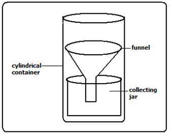
- Constructing a rain gauge
PUPIL’S ACTIVITY
PAGE 53
Materials needed
- A 2-litre plastic bottle
- Ruler
- A ballpoint pen
- Masking tape
- A scalpel or pair of scissors
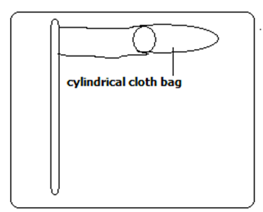
- Constructing a Windsock
PUPIL’S ACTIVITY
PAGE 53-54
Materials needed
- Cylindrical bag
- String
- A scalpel
- Water paints
- An empty plastic fat/magarine tin
- Masking tape or cellotape
- A pole with a pointed end
- Painting brushes or chewed sticks
Significance of weather to human
- Helps us to be aware of natural calamities related to weather before they occur so as to take precautionary measures.
- Guiding tourists on when to visit national parks.
- Helps farmers to plan their activities such as planting, harvesting, etc.
- Ensures air and water transport is carried out safely.
- Helps sporting people to plan their training and competition schedules.
- Helps people to plan many other activities such as mining, electricity generation, holiday events, etc.
- Helps fishing communities to plan their activities
Historical information
Sources of historical information in the society
- Monuments
- Caves
- Historical pictures
- Folk songs
- Old coins
- Recorded folk stories
- Archaeological sites
- Textbooks
- Articles
- Myths
- Artefacts,
- Fossils
Primary and secondary sources of information
Primary source is historical information that are created during the time period studied or were created at a later age by participant in even being practised
Secondary source is historical information that interprets or analyses a historical phenomenon
| Primary sources of historical information | Secondary sources of historical information |
Ways of preserving historical information
Significance of historical information in providing evidence of past accounts
| Sources of historical information | Significance of sources of information | How did it provide evidence of past accounts |
| Primary source | Provide cultural values of the society | They are preserved in museums and cultural centres for viewing |
| Secondary sources | Provide knowledge to students of history | They are stocked in libraries and archives |
PEOPLE AND POLPULATION
HUMAN ORIGIN
TRADITIONAL STORIES ON HUMAN ORIGIN
This is an attempt by communities of people to explain their origin.
It is given through Oral Traditions, myths and legends.
It mainly states that the first people were created by God
- Kikuyu community
According to the Agikuyu, God (Ngai) appeared and created their ancestors (Gikuyu and Mumbi) at Mukurwe Wa Gathanga near present day Muranga
Gikuyu and Mumbi gave birth to 9 daughters who later formed the nine class
- Bukusu
The bukusu of wetern Kenya belives that the fist man was called Mwambu.
He was made from mud by WELE KHAKABA (God the creator) at a place called Mumbo which means west.
God created a wife for him. Mwambu and his wife moved from Mumbo to the foothills of Mt. Masaba-mt elgon- where their descendants grew in numbers to become the Abaluhya community
- Maasai
Once upon a time Enkai (God) owned all the cattle in the world. One day he opened the sky and replaced all the cattle he owned from heaven to earth using a long rope.
Enkai created 3 communities on earth
The Torrobo(also the Ogiek) , the gikuyu whom God bless with seed and grain and the Maasai whom God blessed with all the cattle of the world
- Akamba community
The akamba community believes that God was called Mulungu. He created the first man MUNDU and woman KIVETI.
They were then placed on top of Nzaui Hill in makueni.
He blessed them with children and livestock
- Nandi community
According to the Nandi, the first two people came from the knees of a giant man, which began to swell until they burst. A man came from one knee and a woman from the other. These became the ancestors of the Nandi-speaking people of Kenya. This is an example of myths in certain communities that do not directly refer to God‟s creation.
RELIGIOUS STORIES ON HUMAN ORIGIN
This presents man and everything else as having been created by God.
It is contained mainly in
- The Bible (used by Christians)
God created the heaven and earth according to Genesis chapter 2
- The Quran (used by Muslims).
Islam believes that all living and non living things were created by Allah
- Hindu
The universe was created by Brahma. He is regarded as the hindu god of creation
Factors proving that Africa is the cradle of humankind
- African Savannas were ideal for primates.
- The moist, warm and varied climate supported animal and plant life.
- Archaeological sites were discovered in the Great Lakes region of eastern Africa and along the Great Rift Valley. This confirms that hominids were living in this region by the time the rift valley was being formed.
- The earliest apes and various animals may have first lived around what is now Lake Victoria and the rift valley, then some went northwards into Europe and Asia. This was because, at that time, areas along the Equator (especially central and west Africa) were covered in thick forest. Around the Great lakes of East Africa was the Savannah (grassland with scattered trees and bushes). It was in this environment that man had his first home.
- Due to earth quakes and volcanic eruptions during the formation of the great rift valley, allot of dust was brought up, which covered places where hominids had left their weapons, tools, their own bones, and those of other animals. These became archaeological sites in east Africa
- Remains found in Africa especially Eastern Africa are evidence that Africa is the cradle of mankind.
Evolution is a natural process of gradual and continuous change of living organisms from a lower (simpler) state to a better-adapted (complex) and superior one.
Archaeological site or prehistoric site
Is a place where human remains were found
Archaeologists
Are scientists who excavated the human remains for study
Fossils
Human remains
STAGES OF MAN’S EVOLUTION
- Ramapithecus also called kenyapithecus
The 15-12 million year-old remains of Ramapithecus were found by Mary and Louis Leakey at Fort Ternan near kericho and also at Samburu hills and in the Lakes Turkana and Baringo basins. Ramapithecus and other manlike creatures were also discovered in Europe, India and China.
Characteristics of Ramapithecus
- He was manlike.
- He had small canines.
- He was quadrapedal (he moved on his four limbs), though he occasionally walked on two legs
- Australopithecus/southern ape/zinjathropus
Remains of Australopithecus were found at Taung in Botswana in 1924 by Raymond Dart, at Olduvai Gorge in Tanzania by Mary Leakey in 1959 and throughout eastern Africa e.g. regions around Lake Natron in Tanzania, Lake Turkana in Kenya and Omo River valley in Ethiopia.
Characteristics of Australopithecus
- He was the earliest most manlike hominid.
- He had a pelvis and leg that were similar to modern man‟s.
- He was bipedal (walked on two limbs).
- Could defend themselves.
- Could attack their enemies.
- Could see or sense impending danger from a distance.
- Could grasp objects with ease.
- May have been hairy, short and strong.
- Had a large face and low forehead.
- Had stereoscopic vision.
- Had much larger teeth, skull and jaws.
- His brain was smaller than modern man‟s, but larger than that of the most intelligent ape: the Gorilla.
- Homo habilis (Practical man).
This was the first species of the genus Homo. His two and a half to one and a half million- year old remains were found at Olduvai Gorge by Jonathan Leakey in 1964, Hadar and Omo River valley in Ethiopia and Koobi-For a in the lake Turkana area in 1972.
Characteristics of Homohabilis
- He was five feet tall.
- He had a skull similar to modern man‟s in shape.
- He was omnivorous.
- He could grasp objects.
- He made and used tools.
- HOMOERECTUS (upright man).
Homoerectus lived between two million to two hundred thousand years ago.
- He was five and a half feet tall.
- He was bipedal (walked on two legs).
- He made and used tools, such as hand-axes, crude spears and arrowheads from stone,
- bone and wood.
- Homo sapiens (Thinking/Intelligent man).
Homo sapien appeared between two hundred thousand and a hundred and fifty thousand years ago.
Characteristics of Homosapien
- He was under six feet tall
- He had small teeth.
- He had a steep and well-rounded forehead.
- He had long straight legs.
- He made a variety of more refined tools i.e. microliths.
- He was a fisherman and hunter-gatherer.
- He domesticated plants and animals.
- Remains of Homosapien were found at:
Eliye springs near Lake Turkana,
Kanjera and Kanam in Kenya,
Bodo and Omo river valley in Ethiopia,
Ngaloba in Tanzania.
EARLY CIVILASATION IN AFRICA
Meaning of state, kingdom and Empire
State
A territory is considered as an organised political community under one government
Empire
An extensive group of semi autonomous states ruled by one ruler
Kingdom
A state or territory ruled by a king or queen
The ancient Egypt
Factors that led to growth of Ancient Egypt Civilization
- Presence of river nile
It the annual flood of river nile and the use of shadoof method of irrigation boosted agriculture
- Early technology
It ushered in the bronze stage where copper and tin were used to make simple tools such as chisels and needles
Artisans also made pots for storage and cookery purposes using potter’s wheel
- Population
High population in Ancient Egypt provided ready manpower and market
- Strong military and leadership
They ensured growth of the kingdom through conquests and assimilation of conquered neighbours into the empire
- Use of hieroglyphic
The formal writing helped keep reliable and accurate records in religion, government and history
- Use of the calendar
Tracking of days and monitoring events such as annual flooding of the nile, planting and harvesting period
- Specialised workers
They worked in various institutions. They helped in keeping recods in the Egyptian empire.
They recorded harvest, finances and history
The Great Zimbabwe
Great Zimbabwe was a city near Masvingo in the central part of the modern day Zimabwe, Mozambique and Botstwana.
It existed between 1000BC to 1500BC
Zimbabwe is a shone word meaning “stone houses”
Great Zimbabwe had a centralized government with hereditary kings. This system of government led to the rise and growth of the kingdom
Factors that led to the growth of the Great Zimbabwe civilization
- Strong agricultural economy
- Existence of several minerals deposits such as gold, copper
- Trade
- Strong leadership
- Acquisition of firearms in exchange of goods
- Strong army
- Religious beliefs brought them together
The kingdom of Kongo
Factors that led to the growth of kingdom of Kongo
- Strategic location of the kingdom
- Favourable climate and the kingdom its closeness to congo river which supported agriculture throughout the year
- Arrival of Portuguese
- Religion
- Trade
- Christianity
Locating ancient kingdoms on a map of Africa
Pupil’s activity
Page 77-78
Contributions of early African civilisation to the modern world
- Modern civilisation owes ts current development to the ancient civilization.
- Ancient Egypt was the beginning of building designs and construction of permanent buildings we have today.
- The hieroglyphics form of writing in Egypt used to keep records developed into the modern writing and education
- The knowledge of planning and prediction of seasons based on calendar started in the early civilisation. Today it is has been developed further to include weather forecasting in predicting accurate changes.
- The industrial development in the ancient kingdoms was based on simple skill. Copper and tin were used in ancient Egypt to make items. Today most of the industries use metals and alloys to make construction and infrastructural equipment.
- The modern irrigation technology barrows a lot from the ancient irrigation techniques such as shadoof. This has been applied in the agricultural sector
- Tools such as jembes/hoes used in farming today were developed in the ancient civilisation
- The political structure of modern government resembles the early civilisation goverment
Social organisation of selected African communities up to 1900
Locating areas by the Ogiek, Zulu and Asante communities in Africa
PUPILS’ ACTIVITY
PAGE 81
Social organisation of the Ogiek community up to 1900
Ogiek are southern nilotic speakers
Most of them live in the county of nakuru, mau and mt elgon forests
- Family was the basic unit among the ogiek community
- The lineage was responsible for enforcing traditional law and order
- Father was head of the family
- The ogiek were polygamous
- There was division of labour among the ogiek community
Men provide for the family needs, provide leadership and security
Women worked in homestead, bear children and do household chores
Children helped with household chores, cultivating in farms and artisanship
- The ogiek were a patriarchal society- men owned property and passed it to their sons
- The ogiek believed in one supreme being called Tororet
- They believed also in the existence of ancestral spirits called Oiik
- They had diviners who could foretell the future using supernatural powers
- Both boys and girls were initiated
Boys ceremony was called tumdo op went
Girls ceremony was called tumbo op tiipik
- Intiated boys of the same age group sets known as ipinda
- The ogiek used plants and herbs from forest for treating diseases
Social organisation of the Zulu community up to 1900
Zulu are Ngni people, bantu speaking
They occupy Kwazulu natal province in South africa
In the Ngumi languages izulu means heaven or weather
The zulu clans referred to as the isizwe
The zulu society was organised into parilineal sibs. The sibs were further divide into lineages which were composed of descendants of a common ancestor
Most households comprised extended families who lived in one household called kraal
Men inherited everything. Inheritance was patrilineal
The zulu people were polygamous. Men married many wives and lived with them with the extended family in the kraal.
Men paid dowry in terms of cows and gifts during the weeding day umabo
The zulu community believed in Umhlanga or reeds dance ceremony
Beadwork was a prominent wttire that worn at the Umahlanga
Beadworks was a sign of communication
It also symbolised wealth status of a person
Zulu believed in one God called uNkulunkulu
The controlled day to day human life of the Zulu community
The zulu had traditional mediceine men who treated the sick
Social organisation of the Asante community up to 1900
Asante are Akan speaking people
They live in the central part of the Modern day Ghana
Are organsised into clans whch is headed by a chief
Each clan speaks its own dialect of the Aken language
They believe in one supreme creator called Nyame
Ancestors were believed to connect people to Nyame
Asante empire leader was called Asatehene
He also acted as a spiritual leader
Omamhene and chiefs were all religious leaders who presided over religious ceremonies
Golden stool was th symbol of national unity in the Aasnte empire
It symboised ones and authority from the Asantehene
It was based in Kumasi, the capital of Asant empire
Odwira festival was an annual ceremony
They believed in the spirits of the departed rulers
Asante were socially stratified into 5 main divions
1st division – king and those close to the king
- Lived in the capital of Kumasi
- Were wealthy and lived in luxury
2nd division – consisted of the chiefs and top officials who assisted the king in enforcing law and order
3rd division – those who had acquired a lot of wealth hence respect in the society
4th division – comprised of ordinary farmers, traders and fishermen
5th division – the lowest class was for the slaves
Asante families were extebded and matrilineal – mother’s brother was the legal guardian of her children
Asante were experts in form of decoration, logos, arts, sculture and pottery
These were known as Adinkra symbols
Comparing the social organisation of thr Ogiek, Zulu, and Asante community up to 1900
| Aspect of social organisation | The Ogiek | The Zulu | The Asante |
| Marriage | Polygamous | Polygamous | |
| Initiation ceremony | |||
| Social gender roles | |||
| Art and clothing | |||
| Family set up | |||
| Name of their God | Tororet | believed in one God called uNkulunkulu | supreme creator called Nyame |
| Inheritance | The ogiek were a patriarchal society- men owned property and passed it to their sons | Men inherited everything. Inheritance was patrilineal | |
| Circumcision | Both boys and girls were initiated |
Human diversity and inclusion
Personality attributes which make individuals different from others
Personality attributes are qualities or characteristics that differentiate the character, action and attitude of a person from one another
| Personality attribute | Description |
| Openness to experience | |
| Introversion | |
| Extroversion | |
| Agreeableness | |

Thanks